Ghost Town Trail
- Cambria County Conservation and Recreation Authority
(814) 472-2110 - Indiana County Parks & Trails
(724) 463-8636 - Cambria County Conservation and Recreation Authority
- Indiana County Parks
- Directional Map
-
Trailhead GPS
Coordinates

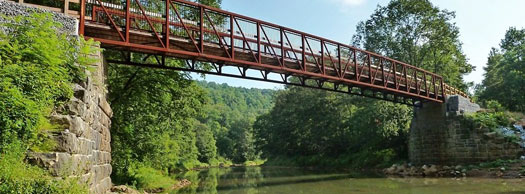
Natural beauty, fascinating historical features, and length: The Ghost Town Trail blends that and throws in a bit of challenge for flavor. Named for the long-gone coal-mining communities that once dotted its right-of-way, the GTT flows past two massive iron furnaces, old coal-loading tipples, boney (coal-refuse) piles and other traces of industrial history. The Blacklick Creek valley in which it is situated is gorgeous, with mountain streams, stands of rhododendron, dozens of wildflower species and cool woodlands.
Trail Description
As it climbs the western slope of the Allegheny Front, the Ghost Town Trail totals 46 miles in length. There is a:
- 32-mile main stem from Blacklick to Ebensburg.
- 4-mile Rexis Branch from Vintondale to U.S. 422.
- 8-mile C&I Branch from U.S. 422 to Expedit Road.
- 2-mile C&I Branch from Vic Miller Road to Snake Road.
With the exception of the C&I Branch, which is unimproved and still under development, the GTT has a crushed limestone surface. At Vintondale, the trail divides and follows two branches of Blacklick Creek.
Trailheads
View Ghost Town Trail in a larger map
Trail Challenges
- Portions of the main stem and Rexis Branch involve extensive climbs, however, all grades are less than 3%.
- Users cross underneath US 422 to connect between the Rexis and C&I branches.
- There is loose ballast for fairly short portions of the C&I Branches.
- There is no trailhead at the end of either C&I branch.